| Touring
routes report home page Table of Contents Previous: The Connecticut Valley Next: Westfield to Northampton |
|
| Touring
routes report home page Table of Contents Previous: The Connecticut Valley Next: Westfield to Northampton |
|
Connecticut Border to Westfield
Cue sheet northbound | Cue sheet southbound
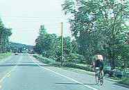
The route from the Connecticut border to Westfield follows Loomis Street, which runs north and south just east of the Berkshire foothills. Loomis Street is very scenic and carries light traffic. It passes a campground, of interest to some bicycle tourists.
The route enters Westfield on Granville Road, passing old mill buildings along the Little River, now converted to housing; and Stanley Park, large, well-landscaped and with recreational facilities.
The route from Connecticut to Westfield will serve primarily as a connection for through-traveling bicycle tourists. There are fewer points of interest along this route than along routes closer to the Connecticut River, but those routes are less scenic and pass through populated areas with heavy motor traffic.
Loomis Street is experiencing some residential development, especially as it approaches Westfield. Fortunately, the parallel Route 10-202, less than a mile to the east, diverts most local traffic from Loomis Street, while Route 5 and Interstate 91, along the west bank of the Connecticut River, carry most long-distance traffic. Given the present pace of development, traffic will remain tolerable for typical bicycle tourists until approximately the year 2010. Then, either Loomis Street will have to be widened or an alternate route developed.
In Westfield, the bicycle touring route must join heavily-traveled Route 10-202 briefly, because the highway bridge is the only crossing of the Westfield River in Westfield.
An additional bridge could effect a major improvement for local and through bicycle travel. The preferred location for such a bridge would be west of the highway bridge, connecting residential neighborhoods and schools, and linking the north-south bicycle touring route without the need to cross Route 10-202. The abutments for a railroad bridge a few hundred feet west of the highway bridge are wide enough to permit the construction of a bicycle-pedestrian bridge alongside, and the banks of the Westfield River offer convenient connections to this bridge from the east and west including the possibility of crossing Route 10-202 under the highway bridge.
| Touring routes report home page Table of Contents Previous: The Connecticut Valley Next: Westfield to Northampton |
Prepared by John S. Allen, 1993 |
 Touring