| Touring
routes report home page Table of Contents Previous: South Berkshire side trips Next: North Berkshire side trips |
|
| Touring
routes report home page Table of Contents Previous: South Berkshire side trips Next: North Berkshire side trips |
|
Main Touring Route, Lenox to Vermont Border
Cue sheet northbound | Cue sheet southbound
The northern half of the Berkshire main route, 50.5 miles long, begins at the main gate of the Tanglewood Music Center at the intersection of Route 183 and Under Mountain Road in Lenox. Passing the Kripalu yoga and meditation retreat center, the route goes west onto Richmond Mountain Road for a steep, 1.7 mile climb to a scenic overlook.
Note that this climb can be avoided via shortcut route 1 (see Shortcuts page).
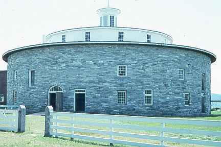
Descending the other side of the mountain takes you into flat-to-rolling Richmond farm country, north along lightly-traveled Route 41 and Dublin Road. The Hancock Shaker Village on Route 20, at the 7-mile mark, is the next major point of interest. This remarkable museum has active exhibits of Shaker workshops, and deserves at least a half-day's visit. The object which looks like a flying saucer in this photo is from the 19th century -- a round barn, elegantly designed so the fooder could be brought in from the upper level, and manure hauled out from the lower level, below the stalls.
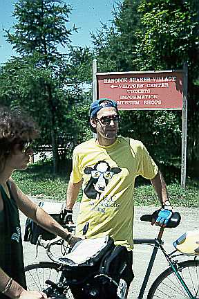
A Vermont Country Cyclers bicycle touring group was visiting Hancock Shaker Village as the author surveyed the route.
Route 20 has wide lanes between Dublin Road and Pittsfield, and is very satisfactory for shared bicycle/motor vehicle use despite the fairly high traffic volume. The bicycle route continues into Pittsfield via Hungerford Street, Fort Hill Avenue and Valentine Road. All of these roads carry relatively light traffic, as they are at the western end of Pittsfield. However, there are lightly traveled secondary streets to take you to the center of Pittsfield.
.
From Valentine Road, you pass though Burbank Park, with its swimming area and picnic tables, and continue into Lanesborough, mostly on Peck's Road. There is a small store on Peck's Road just after Burbank Park.
You next turn north on Route 7 and pass through the classic New England town center of Lanesborough, another place with a store where you can buy refreshments. Note that Route 7 north of Pittsfield has wide shoulders and has just been repaved (1993), making it excellent for bicycle touring despite the moderate to high traffic volume. Lanesborough is the last place to shop before Williamstown, approximately 20 miles ahead.
You next go west over Brodie Mountain Road to Route 43. The climb through the pass south of Brodie Mountain is of only moderate difficulty and length; but a shortcut alternative continuing north on Route 7 is also offered (See Shortcuts), below). The reward for choosing the climb is a ride on one of the most remarkable stretches of highway in Massachusetts; Route 43, through the beautiful Green River Valley. Traveling a short distance south on Route 43 to the New York border, you can visit the center of Hancock and shop there, and make the connection to the published New York bicycle touring route system (see bibliography). However, our route heads north towards Williamstown. Route 43 is newly repaved and carries very little traffic.
Where the bicycle route crosses route 7, it becomes even more pleasant; Green River Road between Route 7 and the center of Williamstown is one of the most beautiful in Massachusetts, and carries very little traffic as it continues to follow the almost level Green River valley. Mount Hope Park offers a picnic area and access to the river. Green River Road ends at Route 2, just east of Williams College.
From here, you travel east on Route 20. Though it carries heavy traffic, it has wide lanes. The bicycle route jogs north via Ashton Avenue
to Massachusetts Avenue, on the north side of the Hoosic River, to avoid a large shopping center which generates heavy crossing and entering traffic. Near North Adams, the bicycle route returns to Route 2 where Massachusetts Avenue becomes narrow and climbs away from the Hoosic River. Both of the crossings of Route 2 are protected by traffic signals.
After passing briefly through North Adams, you climb north to Clarksburg State Park and then to the Vermont border, where the route ends. The linkage here is with Vermont's Route 100, the bicyclist's "backbone" route through Vermont, it is wide, smoothly paved and almost deserted. It makes the connection northward to choice bicycling destinations in central Vermont.
Route 41 in Richmond, though adequate given the present low traffic volume, would no longer be if traffic increases significantly. (Much more traffic presently uses parallel Swamp Road, which connects more directly into Pittsfield.) A good solution for the bicycle touring route would be to pave the southern end of Dublin Road, which the bicycle route now avoids because this is a dirt road. Or Route 41 could be widened, preferably all the way to West Stockbridge.
The bicycle touring route succeeds well in avoiding urban riding in Pittsfield. Roads through the west end of Pittsfield are generally more than adequate -- wide suburban arterials. However, Balance Rock Road in Lanesborough is not very wide, and carries fairly heavy traffic, as it is the only north-south route west of Route 7. Bull Hill Road, connecting Balance Rock Road with Route 7, is even narrower and has a steep hill.
The touring route avoids the worst of this problem by using dirt roads to avoid Bull Hill Road. Despite the dirt surface, these roads are preferable for any bicycles except those with the narrowest racing tires. However, the situation could be improved by widening Peck's Road and either widening Bull Hill Road or paving the dirt roads: Ore Bed Road and Miner Road. A traffic signal might also be needed at Route 7 and Bridge Road, if traffic on Route 7 increases substantially.
The major highways, Routes 20, 7, 43 and 2, used on this segment of the bicycle route are of adequate width. Of these, only Route 2 carries enough traffic to be unpleasant to ride for a significant percentage of the time despite its width. Route 43 is somewhat narrower than the others, but does not and probably never will carry much traffic west of Route 7, due to its location.
Green River Road (Route 43 east of Route 7) could lose its beauty and attractiveness if it becomes the focus of suburban sprawl outside Williamstown. It is a major scenic resource; perhaps zoning could or already does restrict development here. Or perhaps development in its vicinity could be served by a new, parallel road. If not, Green River Road will have to be widened eventually, and will lose the attraction of quiet riding next to a babbling brook, surrounded by green fields.
To avoid the worst congestion in a heavily-traveled corridor, the bicycle alternates between Route 2 and Massachusetts Avenue, the two roads which connect North Adams and Williamstown. Fortunately, Massachusetts Avenue is wide in the middle section where large shopping malls generate crossing and entering traffic on Route 2. However, a more elegant solution could be achieved by widening the parts of Massachusetts Avenue that are now narrow. If the widening were carried all the way to Williamstown, then the bicycle route could pass by the campus of Williams College and cross the Hoosac River at Cole Avenue, avoiding Route 2 entirely.
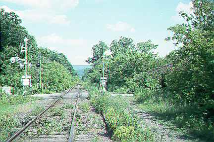
Given the population density, bicycle paths might be justifiable on and near the Williams College campus. Also, a path extending from the center of North Adams to Roberts Drive along the south bank of the river in North Adams would avoid major intersections as well as the climb and descent to Massachusetts Avenue on River Street. Only one track of the two-track railroad right of way between North Adams and Williamstown is in use, and parts of the rail line are used informally by pedestrians and off-road bicyclists.
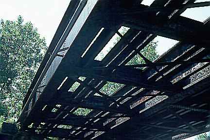
There are serious issues of liability in a bicycle trail along an active rail line. The available separation for a path within the right-of-way is not the preferred 10 feet. Some bridges would need major modifications (here, the one at Roberts Drive).
Also, a trail would not be usable in the winter months when there would still be college-related bicycle traffic.
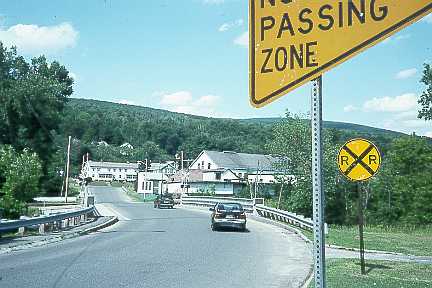
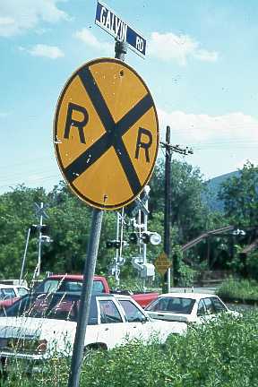
Any improvements in the corridor between Williamstown and North Adams should be undertaken with the understanding that most bicycle traffic will be local, and that access to the shopping areas along Route 2 is therefore important. Crossing of Route 2 is major issue, and would have to be accommodated by signals, considering the traffic volume. There are numerous bridges across the Hoosic River, including three which exclude motor vehicles. One of these is a bridge at Galvin Road (visible in the right background of this photo)
which has been closed to motor traffic, apparently due to structural deterioration. Part of Galvin Road (foreground) is now used as a parking lot. The bridge is still open to bicycles and pedestrians. The political process which resulted in the preservation of the Galvin Road bridge deserves examination.
Improvements to the touring route through North Adams also deserve attention. The route chosen may not be the best; there were too many alternatives to check in the time available. A highway bypass for Route 2 or traffic-calming measures on secondary streets might result in friendlier bicycling conditions in North Adams, the center of which is at present dominated by the intersection of two major highways, with few alternatives available to the bicyclist.
| Touring routes report home page Table of Contents Previous: South Berkshire side trips Next: North Berkshire side trips |
Prepared by John S. Allen, 1993 |
 Touring