 [Massachusetts Bikeways]
[Map]
[Massachusetts Bikeways]
[Boston
(Future)]
[Metro Boston
(Future)]
[Massachusetts Bikeways]
[Map]
[Massachusetts Bikeways]
[Boston
(Future)]
[Metro Boston
(Future)]
[Northeastern Mass.
(Future)]
[Southeastern Mass.
(Future)]
[Central Mass.
(Future)]
[Western Mass.
(Future)]
[Cape Cod and the Islands]
[Bikeways Elsewhere]
[Display with frames]
[Display without map]
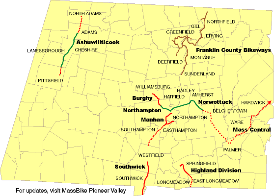
- Ashuwillticook River Trail
(map)
- Running 10.5 miles from Lanesborough to Adams along Rt. 8 and
the Hoosic river, this path is the anchor for a north-south route
from Vermont to Connecticut. The first 5 miles north of Pittsfield
opened August 27, 2001, and construction of the rest is hoped to be complete
by the fall of 2002 or spring of 2003.
There is more information on the
Berkshire Bike Path web site.
-
Northampton Bike Path
- A 2.6-mile paved path on a section of the abandoned New Haven Railroad Canal
Branch which roughly parallels the Connecticut River. A move is afoot to
extend it to Williamsburg, Mass.
- Norwottuck Trail
[map]
[official map]
- This nine-mile-long bikepath connects Amherst and Northampton,
through Hadley, parallelling MA Rt. 9 and avoiding that heavily-travelled road.
With its own bridge over the Connecticut River, it is the
western end of the abandoned Central Mass. railway line, the
eastern end of which is being considered for a Waltham to Hudson
trail. A group in Belchertown is working on extending this path
eastward, and there is a possible connection to a Connecticut
Valley bikeway to New Haven, CT, on the Northampton end.
A connection to the U.Mass. campus
is also being considered.
The state also has
WWW information
available.
Pete's Drive-In, in Hadley,
has a Web page touting its trail access.
There is an
on-line history
of the local Native Americans after whom the trail was named. Check out this
survey of abutters in Hadley.
- Franklin County Bikeway
- This network of bike paths, lanes and routes connects the towns of
the Connecticut River valley in northern Massachusetts.
An
alternate source
of information is also available.
-
Berkshire Bike Path
- The Berkshire Bike Path Council is working on a county-wide effort to
create a path from Vermont to Connecticut. In 1999, they are working
on building community support in Pittsfield and working with the Ashwillticook
path and the town of Adams.
- Greenfield Bikeway
- The Greenfield Bikeway Committee is creating a system of shared-road
bike routes and off-road bike paths to link "schools, businesses, residences,
and other points of interest around town."
-
Manhan Rail Trail
- The Manhan Rail Trail Committee is planning an 8 mile multi-use path
stretching from the southern border of Easthampton MA to downtown Northampton,
with an extra branch out to Mt. Tom Junction near the Oxbow of the
Connecticut River. The trail will eventually connect with the
Norwottuck Trail to Amherst and the
Northampton Bike Path to
Williamsburg.
- Pittsfield Bike Path
- A movement to build bike paths across the City of Pittsfield is growing.
- UMass Connector
- This 2-mile connection between the
Norwottuck Trail and the Amherst campus of the
University of Massachusetts is the highest priority bicycle project in the
Pioneer Valley, but the Massachusetts Highway Department has delayed it so
long that it is losing its ISTEA funding. On September 21, 1999, it was
reported (
1,
2) that
the MHD would find the money to build it even if the ISTEA deadline passed,
and that it would go out to bid by November 1, 1999.
-
Williamsburg Bike Path
[pictures]
- The path will connect to the
Northampton Bike Path at
Look Park and follow a rail right-of-way along the Mill River to
the Haydenville Line. There the Williamsburg section begins. The trail will
follow the Mill River until it reaches Route 9. A Bike Path bridge will
span Route 9, allowing the trail to continue along the railroad bed as it
crosses High Street and parallels Route 9 about 100 yards from the street.
The railroad bed ends at Kellogg Road. There the trail will go along the
edge of Route 9 for a whicle, then curve behind some shops and hug
the riverbank until it ends in Williamsburg center. At some time in the
future the Mill River bridge may be rebuilt, allowing foot and bike
traffic to cross the river at that point. There has been a lot of opposition
to this trail, but the proponets have worked hard and are raising private
money to proceed.
Last updated February 18, 2003 by
Doug Mink