MassPaths
[Massachusetts Bikeways] [Boston (Future)] [Metro Boston (Future)]
[Northeastern Mass. (Future)] [Southeastern Mass. (Future)] [Central Mass. (Future)] [Western Mass. (Future)] [Cape Cod and the Islands] [Bikeways Elsewhere] [Display with frames]

Cape Cod and the Islands Bikeways and Trails

The Cape Cod Trails Conference has a good page on Cape Cod bikepaths and bike ride routes. The Cape Cod Recreation web site has a bike page listing bike rentals and other useful information. William Peace, who has published a bike guide to Cape Cod, also has a lot of information on his web site.
Boston - Cape Cod (Claire Saltonstall) Bikeway [Map]
"Bike Route 1" from Boston to Provincetown is mapped, signed, and marked on the pavement. It starts on the Charles River Bikepath near Boston University, and follows backstreets, backroads, and bikepaths to Cape Cod, with occasional stretches of busier roads. The necessary maps are only available online.

Cape Cod Canal Bikepaths [map] [PDF map]
This pair of bikepaths runs on both sides of the Cape Cod Canal which separates Cape Cod from the rest of Massachusetts. They are maintained by the Army Corps of Engineers and provide a great place from which to watch ships going through the canal and cars stuck in traffic on the bridges.

Cape Cod National Seashore Bikepaths
[Province Lands Map] [Nauset and Truro Maps]
Three paved trails expose bicyclists to a variety of Cape Cod experiences. The Nauset Trail in Eastham, from the Salt Pond Visitor Center, runs from Route 6 to Coast Guard Beach. The Head of the Meadow Trail in Truro travels through an interesting inter-dune area. Watch for the well from which the Pilgrims got their first fresh water after crossing the Atlantic Ocean. The Province Lands Trails, wind through the dunes from Provincetown to Race Point and Herring Cove Beaches. A map is available from the Visitor Centers at Salt Pond in Eastham and in the Province Lands in Provincetown.

Cape Cod Rail Trail [PDF Map]
Recently extended to South Wellfleet, this 25-mile-long trail, mostly off-road, runs up the center of Cape Cod, with few views of the ocean but many encounters with ponds and salt marshes. It connects directly to the Nickerson State Park, which has an extensive system of paved paths and a lot of inexpensive camping. It is managed and maintained by the Massachusetts Department of Environmental Management (Superintendent, Nickerson State Park, P.O. Box 787, Brewster, MA 02631 (508)896-3491). The state has a good free map, and the Cape Cod Rail Trail Bicycle Map, published by The Butterworth Company (350 Main St., West Yarmouth, MA 02673 (508)775-4438), shows all of the roads in the towns through which the Rail Trail passes. The Cape Cod Commission has information on other transportation issues on Cape Cod.

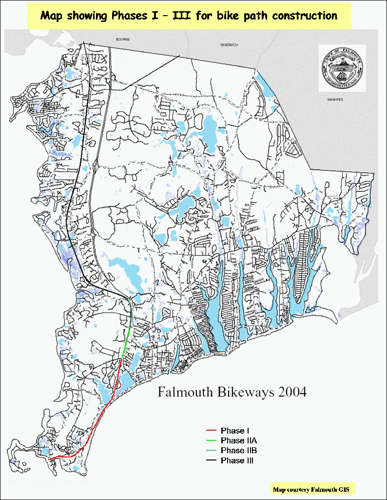
From October 2004 to the spring of 2005, two one-mile sections of the Cape Cod Rail Trail were closed for reconstruction as described by this press release and this map.

Falmouth Shining Sea Trail [map(PDF)] [Guide Book(PDF)]
Four miles of paved bikepath provide an alternate route down the coast to the Woods Hole Ferry Terminal from the center of Falmouth, where free parking is available. For information, contact the Falmouth Bikeway Committee at Falmouth Town Hall, Falmouth, MA 02540 (508)548-7611.

A 0.7-mile extension (Phase IIB) to Carlson Lane is was completed in 2005.

In the spring of 2005, Falmouth Town Meeting voted money to design a 6.5-mile extension (Phase III) to North Falmouth. Voters have to approve the funding before it will be available from a temporary tax increase. Most of the $3M construction cost is expected to come from the state and federal governments. [ Map showing existing and proposed extensions]

Harwich-Chatham Bike Path [Photos]
Branching off from the Cape Cod Rail Trail in a spectacular bicycle rotary (traffic circle to non-New Englanders), this path is finally paved all the way to the center of Chatham. It is fairly well signed, with interesting treatments of major road intersections and includes direct connections to parks and the Harwich Town Hall, and thus picturesque Harwich Center.

Martha's Vineyard [map]
Bikepaths parallel most of the major roads, but there are relatively few intersections, so you can move along pretty well. All Martha's Vineyard Transportation Authority buses have bike racks, and the MVTA island map includes all of the bikepaths. At Menemsha, there is even a bike/pedestrian ferry, which at $4/bike is a bit expensive but worth it for making a loop through Aquinnah doable with a family. While not a cyclists paradise, the island treats bicycles as a real part of the transportation system. There is a nice interactive map of Martha's Vineyard, a mileage table, and an article at Gorp on Biking Martha's Vineyard. For access to the island, check out MassBike's Ferry page.

Nantucket [map]
Bikepaths parallel most of the major roads, and there is a good interactive map online at "Wheels, Heels, & Pedals: The Nantucket Way to Get There" and For access to the island, check out MassBike's Ferry page.

Nickerson State Park [map] [PDF map]
This 1900-acre state park in Brewster has 420 campsites spread out in 7 areas throughout the park, all connected by a system of paved bikepaths as well as the main park road. The park bikepaths include several loops off into the woods which are great for animal watching and studying the landforms and vegetation of Cape Cod. The park paths do not connect directly to the Cape Cod Rail Trail; there is a rather awkward crossing of the main park entrance and a highly-trafficked parking lot, though the distance is only 100 yards or so.

Last updated May 17, 2011 by Doug Mink
[MassPaths Home] [MassPaths Bikeways]